MOS stands for Model Output Statistics. A MOS forecast is derived from the output of weather prediction models developed and run by research meteorologists at NOAA. It determines the statistical relationship between that which is to be predicted and variables forecast by a numerical model at a particular time projection. The use of MOS has actually been around for decades, (since the 1970s) but has only recently been introduced for aviation use. ForeFlight included the MOS imagery in December, 2014.
When planning a flight, the FAA does not recognize MOS as a valid forecast. For instance, you must use the TAF (Terminal Area Forecast) when you are determining if you will need an alternate airport.
ForeFlight contains MOS imagery in their “Imagery” section, listed under “GFS MOS” (Global Forecast System).
MOS ceiling imagery is depicted from 6 hours and every 3 hours through 84 hours.

MOS imagery is also available for Visibility.
Below is a ForeFlight MOS Ceiling image.
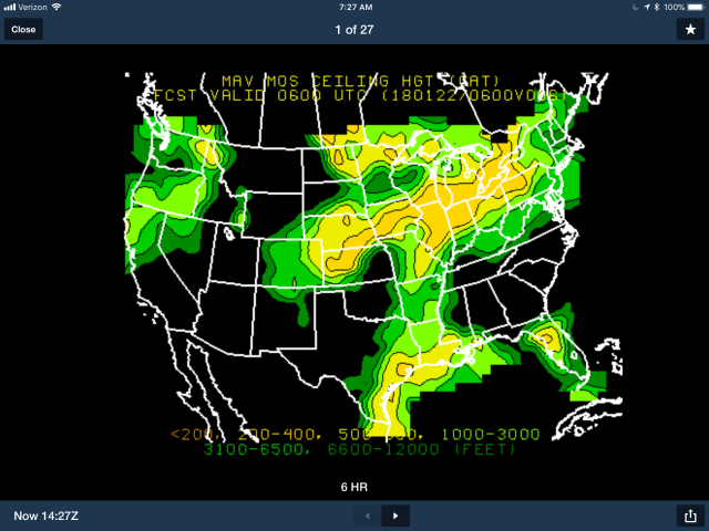
At the bottom of the image, you’ll see the legend. The lighter the green, the higher the ceiling predicted. The browns and yellows indicated ceilings that would not be appropriate for a VFR flight. Dark green indicates possible marginal VFR.
If you don’t have an iOS device, no problem!
FREE and Valid Weather Briefings
You can use Fltplan.com. It’s free and it has a good selection of weather imagery, but lacks the MOS imagery. If you are logged into Fltplan.com and receive their weather briefing, the FAA will consider your briefing valid, as if you had logged into flight service’s website 100wxbrief.com or called flight service for a weather briefing. The same is true if you receive a weather briefing using ForeFlight. In fact, ForeFlight gets your weather briefing from Flight Service.
FREE NOAA MOS Images
You can also see the MOS images at NOAA’s website. Just use the following URL: http://www.nws.noaa.gov/mdl/forecast/graphics/MAV/


The “Ceiling Height/Sky Cover” option has a drop down menu.
I’ve selected the first drop down menu option, “Ceiling Height (Cat)”, shown below. Times are in Zulu.
“Ceiling Height (Cat)” is the same imagery that is displayed on ForeFlight.

As you can see in the drop down menu, NOAA provides many Probabililty (Prob) images that are not found at ForeFlight.
The next time you have a trip planned, as you approach 84 hours prior to your takeoff time, you can watch the ceiling forecast. You’ll have a good idea of the probability that you’ll need to find alternate transportation. It’s just another great tool in your pocket to help you fly safely and have a MOSt excellent adventure.
Jim
